Analysing mangrove forest change using radar.
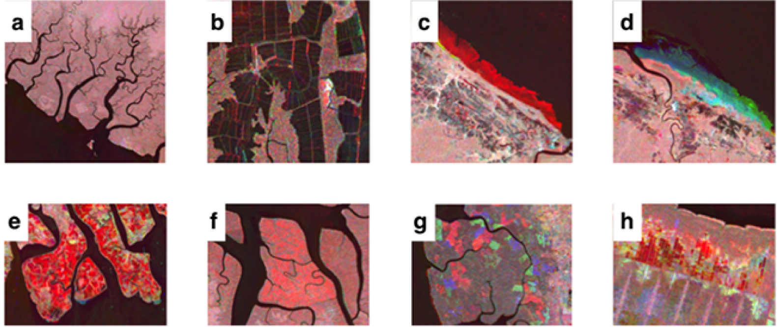 Examples of the categories of change identified within the color composite imagery. Changes in mangrove extent were identified through a combination of their color, their shape and the context of the surrounding environment in the composite imagery. a) intact mangroves in Papua, Indonesia b) prior disturbance (aquaculture) at Guayaquil, Ecuador c) loss of mangrove along the coastline of French Guiana d) colonization of mangrove along the French Guiana coastline e) extensive aquaculture at the Mahakam Delta, East Kalimantan, Indonesia f) mangrove dieback in West Papua, Indonesia g) logging within the managed Matang forest reserve, Perak, Malaysia h) prior and on-going agriculture in Sumatra. Imagery copyright of JAXA. https://doi.org/10.1371/journal.pone.0179302.g001
A recent study mapped the distribution and drivers of global mangrove forest change from 1996 to 2010 [1]. The study, published in PLoS ONE by members of the ALOS Kyoto & Carbon Initiative led by the Japan Aerospace Exploration Agency, investigated the drivers of mangrove land use and land cover change across the tropics using time-series L-band synthetic aperture radar sensors, particularly JER-1 SAR and ALOS/PALSAR mosaic data.
One of the major findings showed that Southeast Asia contained the largest proportion of mangrove forests globally (33.8%), and sadly, the greatest proportion of mangrove forest loss during the 14-year period, mainly as a result of conversion of mangroves for aquaculture/agriculture purposes. The conversion of mangroves into commercial aquaculture ponds has been docmented well in the scientific literature [2-4]. Other categories of change observed in different mangrove areas globally are shown in the figure.
Mangroves are important ecosystems and earth observation technologies such as radar sensors, either spaceborne or airborne, can support the management of these ecosystems. If you are interested to know more, watch the next couple of videos below posted in 2015 and 2016 by Dr Marc Simard, scientist at the NASA Jet Propulsion Laboratory, California Institute of Technology, and one of the co-authors of the study.
Mangroves are coastal ecosystems that provide important services to coastal populations. They offer natural protection against storm surges, hurricanes and tsunamis. Mangroves also contribute to fish stocks by providing nursing grounds for fish and crustaceans. As part of NASA’s Land Cover and Land Use Change program, Simard and his team have developed new remote sensing techniques to monitor the health of mangrove ecosystems. These techniques contribute to support sustainability based decision making with direct societal benefits.
In this next video, a contingent of NASA airborne instruments and scientists on the ground joined colleagues from space agencies in Gabon and Europe to study the dense African tropical forests in Gabon. The forest in this Central African country is the second largest in the world next to the Amazon. During the AfriSAR campaign, the Uninhabited Aerial Vehicle Synthetic Aperture Radar (UAVSAR) flew 40,000-feet high mounted beneath a C-20A aircraft from NASA’s Armstrong Flight Research Center in Edwards, California. Data collected during the two-week AfriSAR campaign will help prepare for and calibrate four current and upcoming spaceborne missions for NASA, ESA, and DLR that aim to, among other goals, better gauge the role of forests in Earth’s carbon cycle.
References:
[1] Thomas N, R Lucas, P Bunting, A Hardy, A Rosenqvist, M Simard. 2017. Distribution and drivers of global mangrove forest change, 1996-2010. PLoS ONE, 12(6): e0179302. [DOI].
[2] Primavera JH. 1995. Mangroves and brakishwater pond culture in the Philippines. Hydrobiologia, 295: 303-309. [DOI].
[3] Hamilton S. 2013. Assessing the role of commercial aquaculture in displacing mangrove forest. Bulletin of Marine Science, 89(2): 585-601. [DOI].
[4] Richards DR, DA Friess. 2016. Rates and drivers of mangrove deforestation in Southeast Asia, 2000–2012. Proceedings of the National Academy of Sciences, 113(2): 344-349. [DOI].
Jose Don T De Alban
carbon markets | redd+ | nbs | conservation | geospatial | land change | sustainability | Southeast Asia