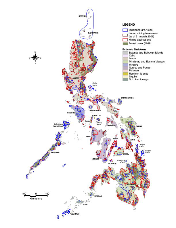
 Overlapping boundaries of Important Bird Areas, mining claims, and forest cover within Endemic Bird Areas.
Abstract
Important Bird Areas (IBA) in the Philippines were identified using a set of international criteria to determine globally important priority areas for biodiversity conservation. The IBA boundaries were delineated using data on trigger bird species distribution coupled with available land cover data. Present conservation work has been guided using the IBAs as a directory of key conservation sites. But how relevant and accurate are the IBA boundaries, considering that less than 50% of Philippine IBAs are completely known ornithologically, and that the original IBA delineation relied on historical records of trigger bird species? The mapping of IBAs illustrated that the original IBA delineation was not well related to forest extents and that 46% of the country’s forest habitats lay beyond IBA boundaries. Forests remained extensive within large Endemic Bird Areas (EBA) but smaller EBAs like Mindoro and Negros Panay had 8% and 5% forests left, respectively. Mining areas were heavily in conflict with IBAs wherein 21% of forests in IBAs were similarly under mining applications. The implications of the gaps in existing IBA boundaries were discussed in light of aggressive promotion of mining and how conservation work and policy agenda in the country could be affected. Challenges and threats in conserving the IBAs at the local and national levels were identified by examining overlaps with mining claims and conflicting tenurial instruments. The revision of original IBA boundaries should be implemented to conform better to forest boundaries, which may form the bases of protected area boundaries. Parameters on delineating IBAs should be developed using updated forest cover information, which can further improve the results of this IBA analysis. The IBA concept should also be applied to Key Biodiversity Areas with the inclusion of data on non-avian taxonomic groups.
Jose Don T De Alban
carbon markets | redd+ | nbs | conservation | geospatial | land change | sustainability | Southeast Asia