Combined Landsat and L-Band SAR data improves land cover classification and change detection in dynamic tropical landscapes
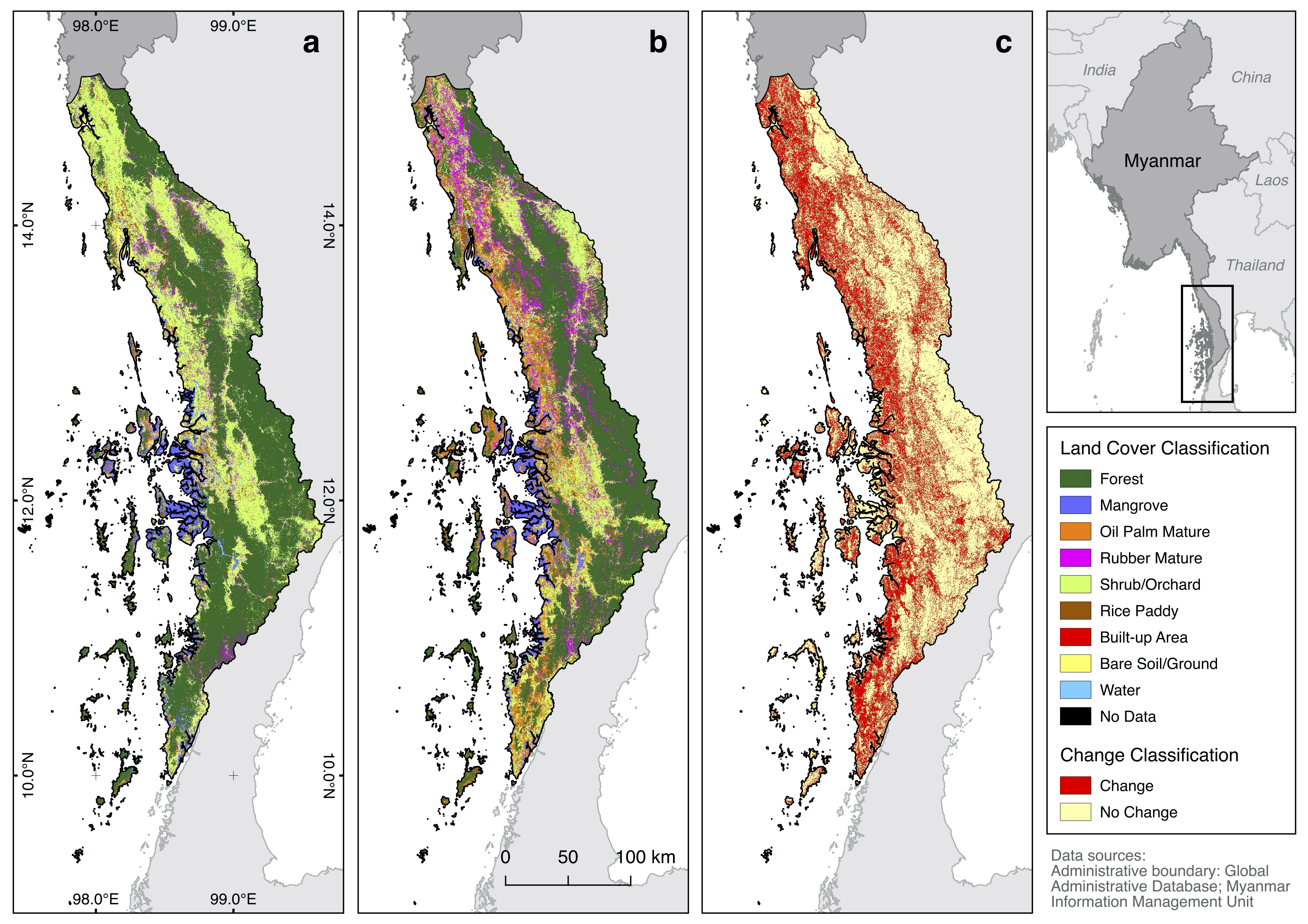 Land cover maps in (a) 1995 and (b) 2015, and © areas of land cover change within the 20-year period in Tanintharyi Region, Myanmar.
Abstract
Robust quantitative estimates of land use and land cover change are necessary to develop policy solutions and interventions aimed towards sustainable land management. Here, we evaluated the combination of Landsat and L-band Synthetic Aperture Radar (SAR) data to estimate land use/cover change in the dynamic tropical landscape of Tanintharyi, southern Myanmar. We classified Landsat and L-band SAR data, specifically Japan Earth Resources Satellite (JERS-1) and Advanced Land Observing Satellite-2 Phased Array L-band Synthetic Aperture Radar-2 (ALOS-2/PALSAR-2), using Random Forests classifier to map and quantify land use/cover change transitions between 1995 and 2015 in the Tanintharyi Region. We compared the classification accuracies of single versus combined sensor data, and assessed contributions of optical and radar layers to classification accuracy. Combined Landsat and L-band SAR data produced the best overall classification accuracies (92.96% to 93.83%), outperforming individual sensor data (91.20% to 91.93% for Landsat-only; 56.01% to 71.43% for SAR-only). Radar layers, particularly SAR-derived textures, were influential predictors for land cover classification, together with optical layers. Landscape change was extensive (16,490 km2; 39% of total area), as well as total forest conversion into agricultural plantations (3214 km2). Gross forest loss (5133 km2) in 1995 was largely from conversion to shrubs/orchards and tree (oil palm, rubber) plantations, and gross gains in oil palm (5471 km2) and rubber (4025 km2) plantations by 2015 were mainly from conversion of shrubs/orchards and forests. Analysis of combined Landsat and L-band SAR data provides an improved understanding of the associated drivers of agricultural plantation expansion and the dynamics of land use/cover change in tropical forest landscapes.
Jose Don T De Alban
carbon markets | redd+ | nbs | conservation | geospatial | land change | sustainability | Southeast Asia